
Land Use and Land Cover Changes and Their Effect on Forest Cover Dynamics: A CA–ANN Model in East Khasi Hills, Meghalaya, India
DOI:
https://doi.org/10.63697/jeshs.2025.015Keywords:
Remote Sensing, CA-ANN, Forest Cover, NDVI, LULCAbstract
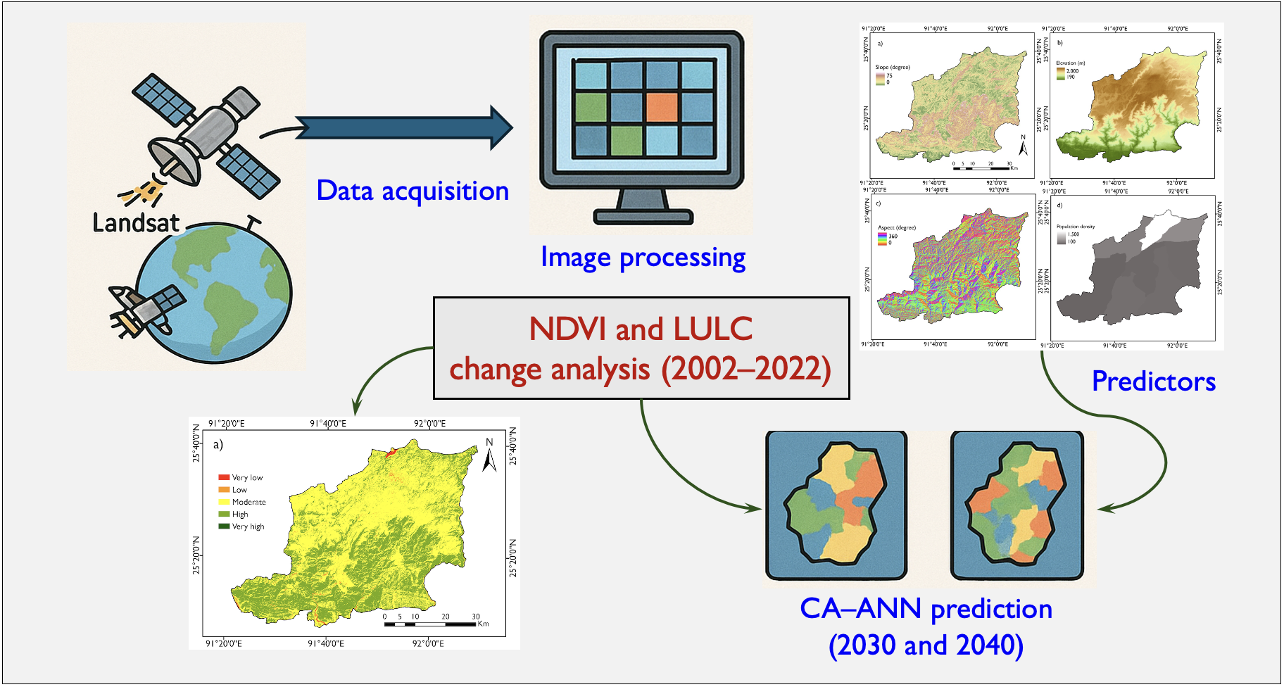
Land use and land cover (LULC) changes, driven by urbanization and human activities, play an important role in forest cover dynamics. Understanding the interactions of these factors is essential for addressing environmental impacts and formulating sustainable policies for forest management. This study investigated the effects of urbanization on LULC changes from 2002 to 2022 using support vector machine (SVM) algorithm in East Khasi Hills, Meghalaya, India. Landsat 7 ETM+ imagery from 2002 and Landsat 8 OLI/TIRS imagery from 2013 and 2022 were used in this study. Seven land use classes, dense forest, moderate forest, sand bar, fallow land, settlement, water body, and agriculture were categorized. Dense forest has declined by 33 km2 from 2002 to 2022, indicating persistent deforestation. Moderate forest expanded until 2013 but declined later in 2022, suggesting degradation. Agricultural land increased gradually by 157 km2 from 2002 to 2022, likely due to shifting cultivation and land reclamation. Water bodies exhibited a minor fluctuation, while fallow land declined by 85 km2. Sand bars remained stable, showing only a minor change, suggesting minimal sedimentation effects. The results suggest the gradual expansion of built-up areas by 30 km2, along with the increase in agricultural lands. The predicted LULC changes for 2030 and 2040 indicate ongoing deforestation and rapid expansion of settlements. A comprehensive study with additional data is needed to help policymakers, particularly those responsible for forest management in the East Khasi Hills, to better understand LULC changes and their impact on forest cover dynamics.
Downloads
References
Abedi Gheshlaghi, H., 2019. Using GIS to develop a model for forest fire risk mapping. Journal of the Indian Society of Remote Sensing, 47, 1173–1185. DOI: https://doi.org/10.1007/s12524-019-00981-z
Almouctar, M.A.S., Wu, Y., Kumar, A., Zhao, F., Mambu, K.J., Sadek, M., 2021. Spatiotemporal analysis of vegetation cover changes around surface water based on NDVI: A case study in Korama basin, Southern Zinder, Niger. Applied Water Science, 11, 4. DOI: https://doi.org/10.1007/s13201-020-01332-x
Baghel, S., Kothari, M.K., Tripathi, M.P., Singh, P.K., Bhakar, S.R., Dave, V., Jain, S.K., 2024. Spatiotemporal LULC change detection and future prediction for the Mand catchment using MOLUSCE tool. Environmental Earth Science, 83, 66. DOI: https://doi.org/10.1007/s12665-023-11381-5
Census of India (Census), 2011. https://censusindia.gov.in/ (accessed on January 14, 2025).
Das, I., 2015. Forest dynamics and prospects of forest resource management in North East India. Pratidhwani the Echo, 3, 32–34.
Dolui, S., Chakraborty, S., 2024. Analyzing the driving factors causing urban sprawl using logistic regression model in greater Shillong planning area, India. In: Rai, P.K., Singh, A., Beingachhi, B., Singh, S.K. (eds) Natural Resources Management and Sustainable Livelihoods in the Mountainous Region. Advances in Geographical and Environmental Sciences. Springer, Singapore. DOI: https://doi.org/10.1007/978-981-97-2100-9_11
Gandhi, G.M., Parthiban, S., Thummalu, N., Christy, A., 2015. Ndvi: Vegetation change detection using remote sensing and Gis – A case study of Vellore District. Procedia Computer Science, 57, 1199–1210. DOI: https://doi.org/10.1016/j.procs.2015.07.415
Gantumur, B., Wu, F., Vandansambuu, B., Tsegmid, B., Dalaibaatar, E., Zhao, Y., 2020. Spatiotemporal dynamics of urban expansion and its simulation using CA-ANN model in Ulaanbaatar, Mongolia. Geocarto International, 37, 494–509. DOI: https://doi.org/10.1080/10106049.2020.1723714
Gao, W., Zheng, C., Liu, X., Lu, Y., Chen, Y., Wei, Y., Ma, Y., 2022. NDVI-based vegetation dynamics and their responses to climate change and human activities from 1982 to 2020: A case study in the Mu Us Sandy Land, China. Ecological Indicators, 137, 108745. DOI: https://doi.org/10.1016/j.ecolind.2022.108745
Giridharan, N., Sivakumar, R., 2022. NDVI based image processing for forest change detection in Sathyamangalam reserve forest. In 2022 2nd International Conference on Technological Advancements in Computational Sciences (ICTACS), Tashkent, Uzbekistan, 731–734. DOI: https://doi.org/10.1109/ICTACS56270.2022.9988184
Hussain, K., Badshah, T., Mehmood, K., Shahzad, F., Anees, S.A., Khan, W.R., Yujun, S., 2025. Comparative analysis of sensors and classification algorithms for land cover classification in Islamabad, Pakistan. Earth Science Informatics, 18, 1–22. DOI: https://doi.org/10.1007/s12145-025-01720-4
Iduseri, E.O., Awoniran, D.R., Izunobi, J.U., Abbas, I.I., Olawole, M.O., 2024. Sustainable development goals, governance and assessment of the impact of urban growth on vegetation cover in Benin City, Nigeria, using land-use–land-cover change trajectories. Discover Sustainability, 5, 291. DOI: https://doi.org/10.1007/s43621-024-00508-8
Islam, M.A., Jimmy, A.N., Alam, M.S., Khan, N.A., 2021. The use of multi-temporal Landsat normalized difference vegetation index (NDVI) data for assessing forest cover change of Lawarchara National Park. Environment, Development and Sustainability, 23, 17702–17722. DOI: https://doi.org/10.1007/s10668-021-01408-x
Islam, M.Y., Nasher, N.R., Karim, K.R., Rashid, K.J., 2023. Quantifying forest land-use changes using remote-sensing and CA-ANN model of Madhupur Sal Forests, Bangladesh. Heliyon, 9, e15617. DOI: https://doi.org/10.1016/j.heliyon.2023.e15617
Krishi Vigyan Kendra (KVK), 2020. East Khasi Hills. District Profile, East Khasi Hills District. Government of Meghalaya. Retrieved [23 February, 2025], from https://kvkeastkhasihills.nic.in/kvkekh/content/districtinfo.php
Kumar, A., Uniyal, S.K., Lal, B., 2007. Stratification of forest density and its validation by NDVI analysis in a part of western Himalaya, India using Remote sensing and GIS techniques. International Journal of Remote Sensing, 28, 2485–2495. DOI: https://doi.org/10.1080/01431160600693583
Liu, Y., Zeng, C., Cui, H., Song, Y., 2018. Sustainable land urbanization and ecological carrying capacity: A spatially explicit perspective. Sustainability, 10, 3070. DOI: https://doi.org/10.3390/su10093070
Liu, S., Liao, Q., Liang, Y., Li, Z., Huang, C., 2021. Spatio–temporal heterogeneity of urban expansion and population growth in china. International Journal of Environmental Research and Public Health, 18, 13031. DOI: https://doi.org/10.3390/ijerph182413031
Marchang, R., 2021. Changing forest land use for agriculture and livelihood in North East India, ISEC WP No. 523, ISEC, Bangalore, 1–18.
Mas, J.-F., 1999. Monitoring land-cover changes: a comparison of change detection technique. International Journal of Remote Sensing, 20, 139–152. DOI: https://doi.org/10.1080/014311699213659
Mehmood, K., Anees, S.A., Muhammad, S., Hussain, K., Shahzad, F., Liu, Q., Ansari, M.J., Alharbi, S.A., Khan, W.R., 2024. Analyzing vegetation health dynamics across seasons and regions through NDVI and climatic variables. Scientific Reports, 14, 11775. DOI: https://doi.org/10.1038/s41598-024-62464-7
Mir, A.H., Sarma, K., Upadhaya, K., 2022. Assessing the effectiveness of community managed forests for plant diversity conservation in Meghalaya, Northeast India. Plant Diversity, 44, 243–254. DOI: https://doi.org/10.1016/j.pld.2021.11.010
Nath, B., Ni-Meister, W., Choudhury, R., 2021. Impact of urbanization on land use and land cover change in Guwahati city, India and its implication on declining groundwater level, Groundwater for Sustainable Development, 12, 100500. DOI: https://doi.org/10.1016/j.gsd.2020.100500
Nath, B., Acharjee, S., 2013. Forest cover change detection using normalized difference vegetation index (NDVI): A study of Reingkhyongkine lake's adjoining areas, Rangamati, Bangladesh. Indian Cartographer, 33, 348–353.
Open Street Map (OSM), 2024. http://www.openstreetmap.org/ (accessed on December 22, 2024).
Paul, S., 2022. Change detection and future change prediction in Habra I and II block using remote sensing and GIS–A case study. International Journal of Engineering and Geosciences, 7, 191–207. DOI: https://doi.org/10.26833/ijeg.975222
Prăvălie, R., Sîrodoev, I., Nita, I.A., Patriche, C., Dumitraşcu, M., Roşca, B., Tiscovschi, A., Bandoc, G., Savulescu, I., Manoiu, V., Birsan, M-V., 2022. NDVI-based ecological dynamics of forest vegetation and its relationship to climate change in Romania during 1987–2018. Ecological Indicators, 136, 108629. DOI: https://doi.org/10.1016/j.ecolind.2022.108629
Rawal, R.S., Bhatt, I.D., Sekar, K.C., Nandi, S.K., 2013. The Himalayan biodiversity: richness, representativeness, uniqueness and life-support values. GB Pant Institute of Himalayan Environment and Development (GBPIHED), Kosi-Katarmal, Almora, Uttarakhand, India, 84pp.
Roy, P.S., Ramachandran, R.M., Paul, O., Thakur, P.K., Ravan, S., Dev Behera, M., Sarangi, C., Ranawade, V.P., 2022. Anthropogenic land use and land cover changes—A review on its environmental consequences and climate change. Journal of the Indian Society of Remote Sensing, 50, 1615–1640. DOI: https://doi.org/10.1007/s12524-022-01569-w
Saikia, A., 2009. NDVI variability in North East India. Scottish Geographical Journal, 125, 195–213. DOI: https://doi.org/10.1080/14702540903071113
Saikia, P., War, P., Umlong, L.M., Nath, B., 2024. Impact of urbanization on urban heat island dynamics in Shillong city, India using google earth engine and CA-Markov modeling. Remote Sensing, 16, 3212. DOI: https://doi.org/10.3390/rs16173212
Sarkissian, A.J., Kutia, M., 2024. Sustainable forest management under climate change conditions—A focus on biodiversity conservation and forest restoration. Frontiers in Forests and Global Change, 7, 1533425. DOI: https://doi.org/10.3389/ffgc.2024.1533425
Singh, A.K., 2010. Probable agricultural biodiversity heritage sites in India: V. the Garo, Khasi, and Jaintia hills region. Asian Agri-History, 14, 133–156.
Sivrikaya, F., Küçük, Ö., 2022. Modeling forest fire risk based on GIS-based analytical hierarchy process and statistical analysis in Mediterranean region. Ecological Informatics, 68, 101537. DOI: https://doi.org/10.1016/j.ecoinf.2021.101537
Tadese, M., Kumar, L., Koech, R., Kogo, B.K., 2020. Mapping of land-use/land-cover changes and its dynamics in Awash River Basin using remote sensing and GIS. Remote Sensing Applications: Society and Environment, 19, 100352. DOI: https://doi.org/10.1016/j.rsase.2020.100352
Talukdar, S., Singha, P., Mahato, S., Pal, S., Liou, Y.A., Rahman, A., 2020. Land-use land-cover classification by machine learning classifiers for satellite observations—A review. Remote Sensing, 12, 1135. DOI: https://doi.org/10.3390/rs12071135
Uddin, M.S., Mahalder, B., Mahalder, D., 2023. Assessment of land use land cover changes and future predictions using CA-ANN simulation for Gazipur City Corporation, Bangladesh. Sustainability 15, 12329. DOI: https://doi.org/10.3390/su151612329
USGS, 2024 Landsat imageries. https://earthexplorer.usgs.gov/ (accessed on December 21, 2024).
Zaitunah, A., Samsuri, Ahmad, A.G., Safitri, R.A., 2018. Normalized difference vegetation index (ndvi) analysis for land cover types using Landsat 8 OLI in besitang watershed, Indonesia. In IOP Conference Series: Earth and Environmental Science, 126, 012112. DOI: https://doi.org/10.1088/1755-1315/126/1/012112
Zhang, Y., Zhang, L., Wang, J., Dong, G., Wei, Y., 2023. Quantitative analysis of NDVI driving factors based on the geographical detector model in the Chengdu-Chongqing region, China. Ecological Indicators, 155, 110978. DOI: https://doi.org/10.1016/j.ecolind.2023.110978
Downloads
Published
Data Availability Statement
The data is included in the manuscript.
Issue
Section
License
Copyright (c) 2025 Parimita Saikia, Dariki S. Langshiang, Lovely Raliang

This work is licensed under a Creative Commons Attribution-NonCommercial-NoDerivatives 4.0 International License.
Authors retain the copyright to their work and grant the journal and its publisher (Enviro Mind Solutions) a non-exclusive license to publish and distribute the work freely.
How to Cite