
Morphometric characterization of the Rani-khola watershed, Sikkim, India, using remote sensing and GIS techniques
DOI:
https://doi.org/10.63697/jeshs.2025.10043Keywords:
Morphometric characteristics, Remote Sensing, Rani-khola watershed, Drainage pattern, Sikkim Himalaya, IndiaAbstract
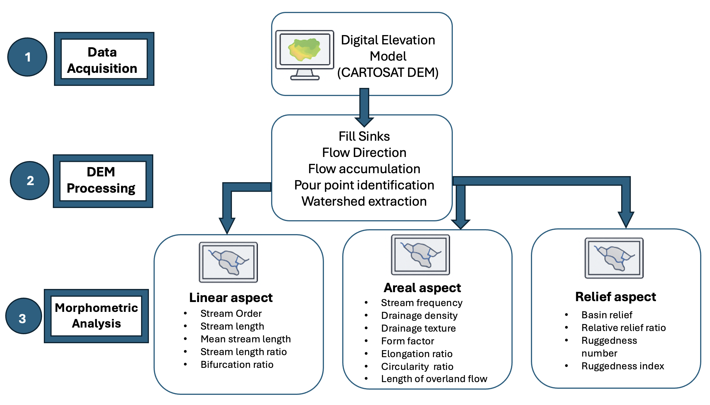
Morphometric analysis is a quantitative method that involves comparison and statistical determination of the physical and hydrological characteristics of a watershed. Remote sensing (RS) and geographic information system (GIS) have been adopted because they provide detailed spatial data used in watershed characterization. Several morphometric parameters have been determined using a remotely sensed digital elevation model (DEM). The study area, the Rani-khola watershed in Sikkim, India, has a regional elevation ranging from 300 to 4,100 m and is bounded by high mountains of the Himalayas and low valleys. Rani-khola stream is a 4th order stream which is also a tributary of river Teesta having a total length of 153.88 km. The mean bifurcation ratio was 1.7, which implies that the basin can be categorized as normal, i.e., containing an elongated and dendritic type drainage pattern. The drainage density and stream frequency of the stream were 0.60 km/km2 and 0.57 streams/km2, respectively, which indicates that the basin exhibits highly permeable subsoil and dense vegetation conditions. The drainage texture of the watershed was calculated as 1.82 km-1, which indicates a very coarse drainage texture. Further studies integrating ground control points would be necessary to develop an appropriate natural resource management plan.
Downloads
References
Ajayakumar, A., Reghunath, R., 2025. Delineation of groundwater recharge zones in lateritic terrains using geospatial techniques. Discover Geoscience, 3(1). DOI: https://doi.org/10.1007/s44288-025-00110-z
Ansari Z.R., Rao L.A.K., Yusuf, A., 2012. GIS based morphometric analysis of Yamuna drainage network in parts of Fatehabad area of Agra district, Uttar Pradesh. Journal Geological Society of India, 79, 505–514. DOI: https://doi.org/10.1007/s12594-012-0075-2
Bhadra, A.K., Pattanayak, S.K., 2025. Drainage Basin Morphometry of Gandhamardan Hills in Western Odisha Using Geographic Information System. In Advances in Geographical and Environmental Sciences (pp. 217–265). Springer Nature Singapore. DOI: https://doi.org/10.1007/978-981-96-1733-3_12
Bogale, A., 2021. Morphometric analysis of a drainage basin using geographical information system in Gilgel Abay watershed, Lake Tana Basin, upper Blue Nile Basin, Ethiopia. Applied Water Science, 11, 122. DOI: https://doi.org/10.1007/s13201-021-01447-9
Chowdhury, M.S., 2024. Morphometric analysis of Halda River basin, Bangladesh, using GIS and remote sensing techniques. Heliyon, 10, e29085. DOI: https://doi.org/10.1016/j.heliyon.2024.e29085
Dey, S., Yadav, V., Pan, S., Chattaraj, S., Bera, S., 2025. Spatio-temporal assessment of land use, climate dynamics, and biophysical parameters in the Ranikhola watershed, Sikkim Himalaya, India. Journal of Water and Climate Change. DOI: https://doi.org/10.2166/wcc.2025.646
Dragičević, N., Karleuša, B., Ožanić, N., 2019. Different approaches to estimation of drainage density and their effect on the erosion potential method. Water, 11, 593. DOI: https://doi.org/10.3390/w11030593
Eze, E.B., Efiong, J., 2010. Morphometric parameters of the Calabar River basin: implication for hydrologic processes. Journal of Geography and Geology, 2, 18. DOI: https://doi.org/10.5539/jgg.v2n1p18
Horton, R.E., 1932. Drainage basin characteristics. Transactions of the American Geophysical Union, 13, 350–361. DOI: https://doi.org/10.1029/TR013i001p00350
Horton, R.E., 1945. Erosional development of streams and their drainage basins; Hydrophysical approach to quantitative morphology. Geological Society of America Bulletin, 56, 275–370. DOI: https://doi.org/10.1130/0016-7606(1945)56[275:EDOSAT]2.0.CO;2
López-Ramos, A., Medrano-Barboza, J.P., Martínez-Acosta, L., Acuña, G.J., Remolina López, J.F., López-Lambraño, A.A., 2022. Assessment of morphometric parameters as the basis for hydrological inferences in water resource management: A case study from the Sinú River basin in Colombia. ISPRS International Journal of Geo-Information, 11, 459. DOI: https://doi.org/10.3390/ijgi11090459
Mahala, A., 2020. The significance of morphometric analysis to understand the hydrological and morphological characteristics in two different morpho-climatic settings. Applied Water Science, 10, 33. DOI: https://doi.org/10.1007/s13201-019-1118-2
Mani, A., Kumari, M., Badola, R., 2022. Morphometric analysis of Suswa river basin using geospatial techniques. Engineering Proceedings, 27, 65. DOI: https://doi.org/10.3390/ecsa-9-13225
Melton, M.A., 1958. Correlation structure of morphometric properties of drainage systems and their controlling agents. The Journal of Geology, 66, 442–460. DOI: https://doi.org/10.1086/626527
Memon, A.V., Patel, Y.S., Parangi, T., 2024. Exploring watershed dynamics: a comprehensive review on morphometric analysis and geospatial techniques. ISH Journal of Hydraulic Engineering, 30, 744–757. DOI: https://doi.org/10.1080/09715010.2024.2383184
Miller, V.C., 1953. A quantitative geomorphic study of drainage basin characteristics in the clinch mountain area, Virginia and Tennessee, Proj. NR 389-402, Tech Rep 3, Columbia University, Department of Geology, ONR, New York.
Nath, N.K., Agrawal, A., Gautam, V.K., Kumar, A., Das, P., 2022. Morphometric evaluation of Ranikhola watershed in Sikkim, India using geospatial technique. Environment Conservation Journal, 23(3), 273–284. DOI: https://doi.org/10.36953/ECJ.10672257
Nayyeri, H., Moradi, R., Sanikhani, H., 2025. Fractal and morphometric characterization of drainage and fault systems in the tectonically active Mereg Basin, Western Iran. International Journal of River Basin Management, 1–18. DOI: https://doi.org/10.1080/15715124.2025.2517831
Pisupati, S.L., Ratnakar, P.J, 2025. Morphometric analysis and prioritization of sub-watersheds in the Gosthani River Basin of southern India using PCA-WSM and geospatial techniques. Journal of Water and Climate Change, 16(6), 2006–2031. DOI: https://doi.org/10.2166/wcc.2025.727
Prabhakaran, A., Jawahar Raj, N., 2018 Drainage morphometric analysis for assessing form and processes of the watersheds of Pachamalai hills and its adjoinings, Central Tamil Nadu, India. Applied Water Science, 8, 31. DOI: https://doi.org/10.1007/s13201-018-0646-5
Robinson, M.J., Scheingross, J.S., 2024. The length and spacing of river tributaries. Proceedings of the National Academy of Sciences USA, 121, e2313899121. DOI: https://doi.org/10.1073/pnas.2313899121
Sakthivel, R., Jawahar Raj, N., Sivasankar, V., Akhila, P., Omine, K., 2019. Geo-spatial technique-based approach on drainage morphometric analysis at Kalrayan Hills, Tamil Nadu, India. Applied Water Science, 9, 24. DOI: https://doi.org/10.1007/s13201-019-0899-7
Schumm, S.A., 1956. Evolution of drainage systems and slopes in Badlands at Perth Amboy, New Jersey. Geological Society of America Bulletin, 67, 597–646. DOI: https://doi.org/10.1130/0016-7606(1956)67[597:EODSAS]2.0.CO;2
Shekar, R.P., Mathew, A., 2024. Morphometric analysis of watersheds: A comprehensive review of data sources, quality, and geospatial techniques. Watershed Ecology and the Environment, 6, 13–25. DOI: https://doi.org/10.1016/j.wsee.2023.12.001
Shekar, P.R., Mathew, A., 2022. Evaluation of Morphometric and Hypsometric Analysis of the Bagh River Basin using Remote Sensing and Geographic Information System Techniques. Energy Nexus, 7, 100104. DOI: https://doi.org/10.1016/j.nexus.2022.100104
Sonker, I., Tripathi, J.N., Swarnim, Singh, A.K., 2023. Morphomertic and neotectonic study of Upper Teesta River basin, Sikkim Himalaya using geospatial techniques. Journal of Applied Geophysics, 212, 104978. DOI: https://doi.org/10.1016/j.jappgeo.2023.104978
Strahler, A.N., 1957. Quantitative analysis of watershed geomorphology. Transactions of the American Geophysical Union, 38, 913–920. DOI: https://doi.org/10.1029/TR038i006p00913
Strahler, A.N., 1964. Quantitative geomorphology of drainage basins and channel networks. In: Chow, V., Ed., Handbook of Applied Hydrology. McGraw Hill Book Company, New York, 439–476.
Sukristiyanti, S., Maria, R., Lestiana, H., 2018. Watershed-based morphometric analysis: a review. IOP Conference Series: Earth and Environmental Science, 118, 012028. DOI: https://doi.org/10.1088/1755-1315/118/1/012028
Todorovic, M., Stedito, P., 2003. A GIS for irrigation management. Physics and Chemistry of the Earth, 28, 163–174. DOI: https://doi.org/10.1016/S1474-7065(03)00023-8
Uniyal, S., Gupta, P., 2013. Prioritization based on morphometric analysis of Bhilangana watershed using spatial technology. International Journal of Remote Sensing & Geoscience, 3, 49–57.
Vijith, H., Satheesh, R., 2006. GIS Based morphometric analysis of two major upland sub-watersheds of Meenachil River in Kerala. Journal of the Indian Society of Remote Sensing, 34, 181–185. DOI: https://doi.org/10.1007/BF02991823
Vitalla, S.S., Govindaiah, S., Gowda, H.H., 2004. Morphometric analysis of sub-Watersheds in the Pavagada area of Tumkur district, South India using remote Sensing and GIS techniques. Journal of the Indian Society of Remote Sensing, 32, 351–362. DOI: https://doi.org/10.1007/BF03030860
Waiker, M.L., Nilawar, A.P., 2014. Morphometric analysis of a drainage basin using geographical information system: A case study. International Journal of Multidisciplinary and Current Research, 2, 179–184.
Yunus, A.P., Oguchi, T., Hayakawa, Y.S., 2014. Morphometric analysis of drainage basins in the western Arabian Peninsula using multivariate statistics. International Journal of Geosciences, 5, 527–539. DOI: https://doi.org/10.4236/ijg.2014.55049
Downloads
Published
Data Availability Statement
The data that supports this research will be shared upon reasonable request to the corresponding authors.
Issue
Section
License
Copyright (c) 2025 Deepan Rizal, Ghanashyam T. Patle, Parimita Saikia

This work is licensed under a Creative Commons Attribution-NonCommercial-NoDerivatives 4.0 International License.
Authors retain the copyright to their work and grant the journal and its publisher (Enviro Mind Solutions) a non-exclusive license to publish and distribute the work freely.
How to Cite