
Comparative analysis of normalized difference index for assessing urbanization, forest degradation, and water body changes: A case study of Sylhet and Gazipur districts, Bangladesh
DOI:
https://doi.org/10.63697/jeshs.2026.10078Keywords:
Urbanization, Forest degradation, Water body changes, Land cover changes, BangladeshAbstract
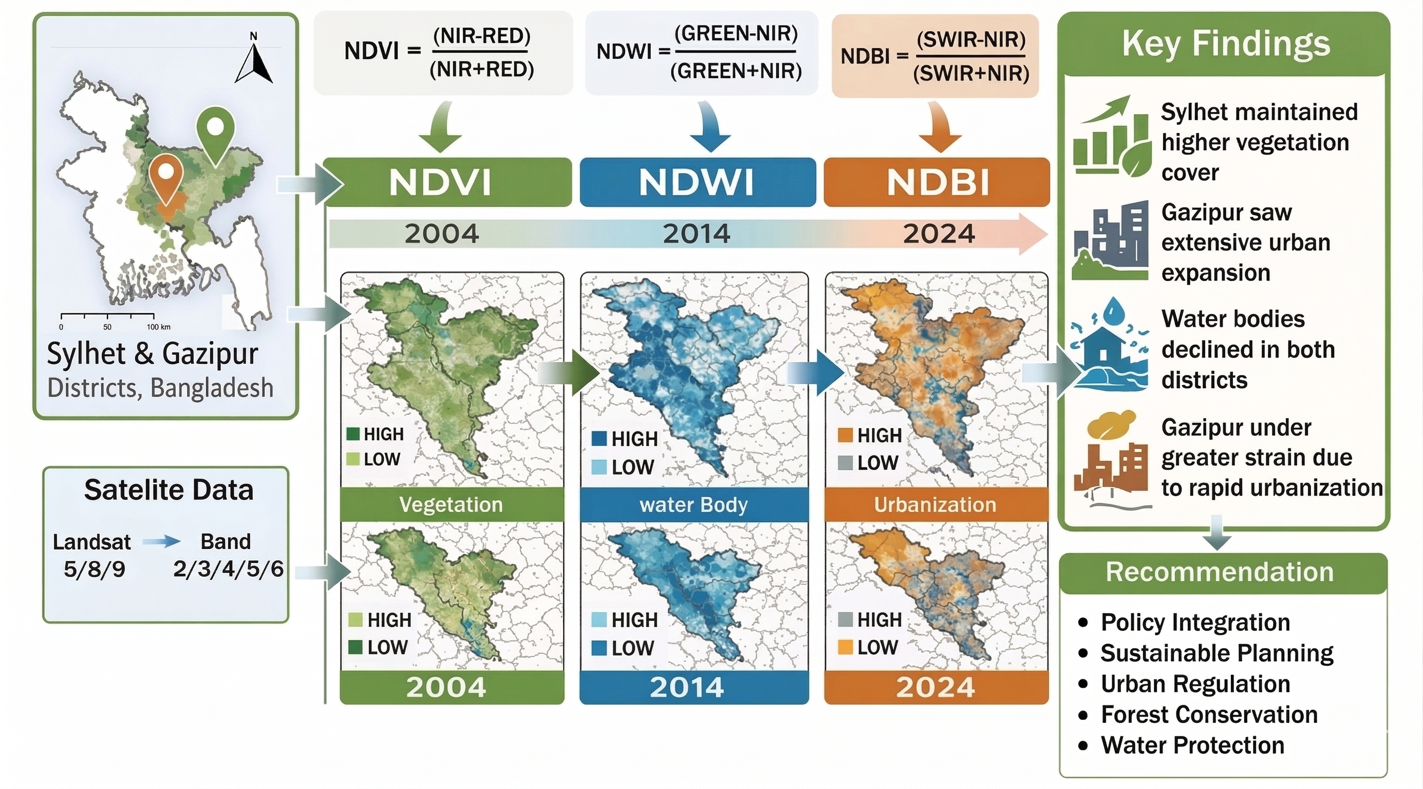
Bangladesh has experienced rapid urbanization in recent years, leading to significant ecological changes. This study examines land cover variations in Sylhet and Gazipur districts, with an emphasis on vegetation, urbanization, and water bodies, to assess the environmental impacts of urban development, including decreased vegetation. Remote sensing data from 2004 to 2024 were analyzed using Geographic Information System (GIS) to identify long-term changes through the Normalized Difference Vegetation Index (NDVI), Normalized Difference Built-up Index (NDBI), and Normalized Difference Water Index (NDWI). The seasonal variations were highlighted through separate examinations of the data. The outcomes revealed different trajectories for the two districts. NDVI analysis indicates contrasting vegetation dynamics between the two districts. In Sylhet, winter NDVI declined by 9.05% over the 2004–2024 period, while summer NDVI increased by 11.52%, reflecting seasonal growth variability but ecological sensitivity. In contrast, Gazipur recorded modest vegetation gains (5.25% in winter and 0.32% in summer), suggesting limited recovery amid developmental pressures. NDBI trends reveal substantially stronger urban expansion in Gazipur, where built-up intensity increased by 59.7% in winter and 16.33% in summer, compared to seasonal declines in Sylhet (10.21% in winter and 31.67% in summer). Water body dynamics further highlight divergence: Sylhet experienced marked NDWI reductions (41.39% in winter and 21.43% in summer), whereas Gazipur showed seasonal instability, with a 12.31% winter increase but a sharp 34.3% summer decline. Overall, Sylhet appears less urbanized but hydrologically vulnerable, while Gazipur demonstrates pronounced urban-driven ecological strain. These findings demonstrate the urgent need for sustainable planning through planned reforestation, green space conservation, and effective water resource management, among other measures, to minimize ecological degradation.
Downloads
References
Abir, F. A., & Saha, R. (2021). Assessment of land surface temperature and land cover variability during winter: A spatio-temporal analysis of Pabna municipality in Bangladesh. Environmental Challenges, 4, 100167. DOI: https://doi.org/10.1016/j.envc.2021.100167
Al-Issawi, R. J. M., & Al-Falahi, A. S. H. (2022). Use of evidence NDVI, NDBI, NDWI, MSAVI to reveal the uses of agricultural land in karma district using modern technologies. International Journal of Health Sciences, 6, 8203–8219. DOI: https://doi.org/10.53730/ijhs.v6nS6.11945
Alademomi, A. S., Okolie, C. J., Daramola, O. E., Akinnusi, S. A., Adediran, E., Olanrewaju, H. O., Alabi, A. O., Salami, T. J., & Odumosu, J. (2022). The interrelationship between LST, NDVI, NDBI, and land cover change in a section of Lagos metropolis, Nigeria. Applied Geomatics, 14(2), 299–314. DOI: https://doi.org/10.1007/s12518-022-00434-2
Aslan, N., & Koc-San, D. (2021). The use of land cover indices for rapid surface urban heat island detection from multi-temporal Landsat imageries. ISPRS International Journal of Geo-Information, 10(6), 416. DOI: https://doi.org/10.3390/ijgi10060416
Bhatti, S. S., & Tripathi, N. K. (2014). Built-up area extraction using Landsat 8 OLI imagery. GIScience & Remote Sensing, 51(4), 445–467. DOI: https://doi.org/10.1080/15481603.2014.939539
Chandramohan, K., Elayapillai, P., Vijayalakshmi, G., & Kaliraj, S. (2024). Evaluating the relation of NDVI, NDWI, SMI, and LAI to land and soil degradation processes — a case study of Virudhunagar district, Tamil Nadu, India. In Remote Sensing of Soils (pp. 689–697). Elsevier. DOI: https://doi.org/10.1016/B978-0-443-18773-5.00040-5
Das, A. C., Shahriar, S. A., Chowdhury, M. A., Hossain, M. L., Mahmud, S., Tusar, M. K., Ahmed, R., & Salam, M. A. (2023). Assessment of remote sensing-based indices for drought monitoring in the north-western region of Bangladesh. Heliyon, 9(2), e13016. DOI: https://doi.org/10.1016/j.heliyon.2023.e13016
Essaadia, A., Abdellah, A., Ahmed, A., Abdelouahed, F., & Kamal, E. (2022). The normalized difference vegetation index (NDVI) of the Zat valley, Marrakech: comparison and dynamics. Heliyon, 8(12), e12204. DOI: https://doi.org/10.1016/j.heliyon.2022.e12204
Eshtawi, T., Evers, M., & Tischbein, B. (2016). Quantifying the impact of urban area expansion on groundwater recharge and surface runoff. Hydrological Sciences Journal, 61(5), 826–843. DOI: https://doi.org/10.1080/02626667.2014.1000916
Faisal, A. A., Hossain, M. A., Haque, S., Shaunak, M. F., & Kafy, A. A. (2019). Remote sensing approach in wetland and land degradation assessment: A scenario of Modhumoti model town, Savar, Bangladesh. 1st International Conference on Urban and Regional Planning, Bangladesh Institute of Planners (BIP).
Fatima, N., Alamgir, A., Khan, M. A., Fatima, S. U., & Malik, E. (2022). Monitoring of environmental resources using normalized difference vegetation index (NDVI) and normalized differences water index (NDWI) in the Coastal areas of Sindh, Pakistan. International Journal of Biology and Biotechnology, 19(3), 379–393.
Foley, J. A., DeFries, R., Asner, G. P., Barford, C., Bonan, G., Carpenter, S. R., Chapin, F. S., Coe, M. T., Daily, G. C., Gibbs, H. K., Helkowski, J. H., Holloway, T., Howard, E. A., Kucharik, C. J., Monfreda, C., Patz, J. A., Prentice, I. C., Ramankutty, N., & Snyder, P. K. (2005). Global consequences of land use. Science, 309(5734), 570–574. DOI: https://doi.org/10.1126/science.1111772
Guha, S., & Govil, H. (2022). Analyzing the relationship of LST with MNDWI and NDBI in urban heat islands of Hyderabad City, India. In Geospatial Modeling for Environmental Management (pp. 241-258). CRC Press. DOI: https://doi.org/10.1201/9781003147107-16
Guha, S., Govil, H., & Diwan, P. (2019). Analytical study of seasonal variability in land surface temperature with normalized difference vegetation index, normalized difference water index, normalized difference built-up index, and normalized multiband drought index. (2019). Journal of Applied Remote Sensing, 13(02), 024518. DOI: https://doi.org/10.1117/1.JRS.13.024518
Hassan, T., Zhang, J., Prodhan, F. A., Pangali Sharma, T. P., & Bashir, B. (2021). Surface urban heat islands dynamics in response to LULC and vegetation across South Asia (2000–2019). Remote Sensing, 13(16), 3177. DOI: https://doi.org/10.3390/rs13163177
Imran, H. M., Hossain, A., Islam, A. K. M. S., Rahman, A., Bhuiyan, M. A. E., Paul, S., & Alam, A. (2021). Impact of land cover changes on land surface temperature and human thermal comfort in Dhaka City of Bangladesh. Earth Systems and Environment, 5(3), 667–693. DOI: https://doi.org/10.1007/s41748-021-00243-4
Khine, M. M., Maw, Y. Y., & Win, K. M. M. (2018). Change analysis of indices (NDWI, NDVI, NDBI) for Mawlamyine City area using google earth engine. Journal of Myanmar Academy of Arts and Sciences, 16(5), 297–313.
Mathew, A., Sarwesh, P., & Khandelwal, S. (2022). Investigating the contrast diurnal relationship of land surface temperatures with various surface parameters represent vegetation, soil, water, and urbanization over Ahmedabad city in India. Energy Nexus, 5, 100044. DOI: https://doi.org/10.1016/j.nexus.2022.100044
McFeeters, S. K. (1996). The use of the Normalized Difference Water Index (NDWI) in the delineation of open water features. International Journal of Remote Sensing, 17(7), 1425–1432. DOI: https://doi.org/10.1080/01431169608948714
Mehmood, K., Anees, S. A., Muhammad, S., Hussain, K., Shahzad, F., Liu, Q., Ansari, M. J., Alharbi, S. A., & Khan, W. R. (2024). Analyzing vegetation health dynamics across seasons and regions through NDVI and climatic variables. Scientific Reports, 14(1), 11775. DOI: https://doi.org/10.1038/s41598-024-62464-7
Pettorelli, N., Vik, J. O., Mysterud, A., Gaillard, J.-M., Tucker, C. J., & Stenseth, N. Chr. (2005). Using the satellite-derived NDVI to assess ecological responses to environmental change. Trends in Ecology & Evolution, 20(9), 503–510. DOI: https://doi.org/10.1016/j.tree.2005.05.011
Roy, S., Pandit, S., Eva, E. A., Bagmar, Md. S. H., Papia, M., Banik, L., Dube, T., Rahman, F., & Razi, M. A. (2020). Examining the nexus between land surface temperature and urban growth in Chattogram Metropolitan Area of Bangladesh using long term Landsat series data. Urban Climate, 32, 100593. DOI: https://doi.org/10.1016/j.uclim.2020.100593
Salam, M., Islam, Md. K., Jahan, I., & Chowdhury, Md. A. (2024). Assessing the impacts of vegetation loss and land surface temperature on Surface Urban Heat Island (SUHI) in Gazipur District, Bangladesh. Computational Urban Science, 4(1). DOI: https://doi.org/10.1007/s43762-024-00136-y
Seto, K. C., Güneralp, B., & Hutyra, L. R. (2012). Global forecasts of urban expansion to 2030 and direct impacts on biodiversity and carbon pools. Proceedings of the National Academy of Sciences, 109(40), 16083–16088. DOI: https://doi.org/10.1073/pnas.1211658109
Sharma, N., & Arote, G. (2022). Mercury rising: Examining LST Links with NDVI, NDWI, NDBI & SMI in the Kamrup Metropolitan District, India Using Geospatial Technologies. In Environmental Change in South Asia (pp. 71–91). Springer International Publishing. DOI: https://doi.org/10.1007/978-3-030-47660-1_5
Sharma, R., & Joshi, P. K. (2016). Mapping environmental impacts of rapid urbanization in the National Capital Region of India using remote sensing inputs. Urban Climate, 15, 70–82. DOI: https://doi.org/10.1016/j.uclim.2016.01.004
Tucker, C. J. (1979). Red and photographic infrared linear combinations for monitoring vegetation. Remote Sensing of Environment, 8(2), 127–150. DOI: https://doi.org/10.1016/0034-4257(79)90013-0
Ukhnaa, M., Huo, X., & Gaudel, G. (2019). Modification of urban built-up area extraction method based on the thematic index-derived bands. IOP Conference Series: Earth and Environmental Science, 227, 062009. DOI: https://doi.org/10.1088/1755-1315/227/6/062009
United Nations, 2020. https://www.un.org/uk/desa/68-world-population-projected-live-urban-areas-2050-says-un
Xu, H. (2008). A new index for delineating built‐up land features in satellite imagery. International Journal of Remote Sensing, 29(14), 4269–4276. DOI: https://doi.org/10.1080/01431160802039957
Zha, Y., Gao, J., & Ni, S. (2003). Use of normalized difference built-up index in automatically mapping urban areas from TM imagery. International Journal of Remote Sensing, 24(3), 583–594. DOI: https://doi.org/10.1080/01431160304987
Zhao, C. S., Pan, T. L., Yang, S. T., Sun, Y., Zhang, Y., Ge, Y. R., Dong, B. E., Zhang, Z. S., & Zhang, H. M. (2019). Quantifying the response of aquatic biodiversity to variations in river hydrology and water quality in a healthy water ecology pilot city, China. Marine and Freshwater Research, 70(5), 670–681. DOI: https://doi.org/10.1071/MF18385
Zheng, Y., Tang, L., & Wang, H. (2021). An improved approach for monitoring urban built-up areas by combining NPP-VIIRS nighttime light, NDVI, NDWI, and NDBI. Journal of Cleaner Production, 328, 129488. DOI: https://doi.org/10.1016/j.jclepro.2021.129488
Downloads
Published
Data Availability Statement
The corresponding author can provide additional materials, such as processed datasets, analytical methods, and accompanying figures, following an appropriate request.
Issue
Section
License
Copyright (c) 2026 Tonmoy Banik, Ashraf Ali Seddique

This work is licensed under a Creative Commons Attribution-NonCommercial-NoDerivatives 4.0 International License.
Authors retain the copyright to their work and grant the journal and its publisher (Enviro Mind Solutions) a non-exclusive license to publish and distribute the work freely.
How to Cite